The trip
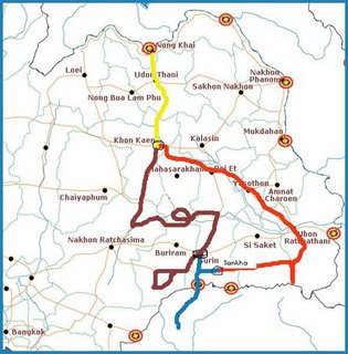
So, we had a basic outline of what we were going to do. We were going to see Khao Prah Wihan (Preah Vihear) on the Thai-Cambodian border, and were going to go about 120 KM into northwest Cambodia to see Banteay Chhmar (pronounced Chmaa-a but spelled with 2 h's for some reason). And we had a reservation in Khon Kaen for Friday night. Beyond that, we were footloose and fancy free. Our route is below; yellow is Friday night, red is Saturday, blue is Sunday, the purplish is Monday, and today is represented by yellow again, as we stayed in Khone Kaen last night too.
So it seems that in our 1104 miles, we covered quite a bit of Northeastern Thailand, also called Isan. Isan culture and language is similar to Thai, so everyone we talked to was pleasantly surprised at the two farangs who were speaking Lao. As such, we drew a crowd, and had alot of fun talking to the locals.
The red that extends down to the Cambodian border is Khao Prah Wihan and the blue into Cambodia is Banteay Chhmar. The purplish day was basically our free day as we had accomplished all (read 'both') our intended tasks. As such, the line is much more meandering and unfocused. The bottom loop we did, the top loop, not quite. We did, however, work our way through some roads that were not on the atlas (yes, the 2006 Thailand atlas. we were on small roads). Lots of stopping at T-stops and asking farmers which way to Satuk.
All in all a fun time, although the Thai have a strange habit of making sharp Z-typ turns in their country roads. Not sure why, but it did result in a few hair-raising, screeching turns before we figured out that the Z turns were a common theme on the back roads of Surin District.
So we stayed in Khon Kaen, Sangkha, Surin, and Khon Kaen again. And now we are home.

map courtesy of travelfish.org (okay, map stolen from travelfish.org)
pictures coming.


0 Comments:
Post a Comment
<< Home