Herein lies the UXO problem in Laos
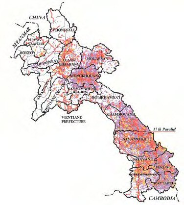
This map shows bomb data from the war, and this is just the aerial bombs. Doesn't include mortars or any other type of ordnance not dropped from planes.
Notice the deep red in the middle of the country. This is the Plain of Jars, a plateau, that, unfortunately for the people living there at the time (and today, given the UXO accidents that still happen often), was the flat land between the North Vietnamese Army and Pathet Lao forces on one side (coming in from Huaphan to the north and North Vietnam to the east) and the Royalist Army and Hmong soldiers from the south and west.
And the southern part of the country was the Ho Chi Minh Trail. Red means REALLY bombed, yellow means VERY bombed, and purple means bombed more than you would want your town bombed X 10. As you know, I was recently in Sekong Province. A very colorful province on this map.
The 17th parallel is shown, which is where North and South Vietnam were separated. As such, the HCM Trail started just above the 17th parallel and ran down to numerous exits into South Vietnam. At the height of the war the NVA was moving over 20,000 troops and tons of equipment down the trail per month. As such, it was bombled heavily.
We are finalizing our assistance plan for 2006 (which, in actuality, runs from July 1, 2006 to June 30, 2007, go figure). I'll let y'all know what the USG will be doing once it's final and public.
posted by Katherine and Phil @ 5:54 PM
![]()
![]()

0 Comments:
Post a Comment
<< Home